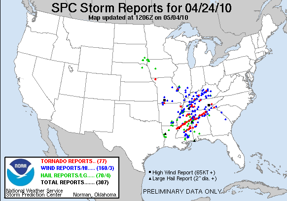
I had the pleasure of being tapped as Brett Adair's accompaniment for the supposed high risk outlook/tornado outbreak in Arkansas this past Saturday.
08Z. The alarms are going off and I crawl out of bed. I pack the car and head to Talladega County to Brett's house. I arrive shortly after 12Z and we begin loading equipment into the truck and hooking up streaming cameras, GPS transmitters, and internet to the laptop. By 1315Z we were on the road with an initial target of Helena, Arkansas. After pit stops we get on US 278 in Tupelo, MS and head for Oxford around 1530Z. Cells are already popping along the River and trekking northeast. As we're passing through Oxford, a cell immediately to our west goes tornado warned. We accelerate and while trying to get there for an intercept, the cell to its south goes tornado warned. We backed off and waited for the second cell to meet the road, basically allowing the cell to intercept us. We can see rotation and a nicely formed wall cloud. We race westward to get a closer look and the storm takes somewhat of a "right" (east) turn and starts moving the rotation directly down US 278. Perfect. We're ready and in perfect position. The precipitation shield quickly wrapped around the Rear Flank Downdraft (in bold because herein it shall be referred to as "RFD"), and mostly obscured the main rotation. We parked in a median crossing and looked at the latest velocity scans. As I was looking, Brett looked out the windshield and said "FUNNEL!! Passing directly over us!!". That storm continued on and later produced damage in northeast Mississippi and northwest Alabama. We weren't too worried with it as the "main show" was yet to come in Arkansas.
We continued west-bound on US278 until we reached US61 just northeast of Clarksdale where we proceeded north to cross the Mississippi River into Arkansas. We stopped in Helena, AR after crossing and met with ChaserTV storm chaser John Sibley. Several cells started popping to our southwest so we deployed for intercept. The towers would go up quickly and immediately start rotating in the great amount of low level shear then get sheared apart. Updrafts were having a hard time sustaining themselves. We witnessed two cells go through this cycle. Both produced very weak-looking, small funnels for a very brief time, and Sibley took a photo of a storm with a small debris cloud visible. We proceeded west on US49 then south on US79 toward Stuttgart. Chaser convergence became very apparent as there were at least fifteen markers on Spotter Network in the Stuttgart area. We got on US165 and headed west toward the small town of Humnoke, AR where we crossed paths with some meteorology students from The University of Louisiana-Monroe, and Randy "The Outlaw" Hicks. We were stationary for nearly an hour and a half doing analysis and talking with the other chasers, then we dove south on state road 13 back to US79 and headed toward Pine Bluff. During this time the radar lit up like a Christmas tree in northern Louisiana and southern Arkansas. We intercepted our first storm on the southern edge of Pine Bluff around 00Z. We witnessed a well-defined wall cloud with this storm. We were proceeding to stop on an exit ramp and witnessed a funnel cloud and a very, very brief debris cloud under it. Then to the left just ahead of the RFD, a gustnado appeared for roughly 30 seconds.
We dove southward even further on US63 and intercepted the storm to its south that had much better presentation on both base reflectivity and velocity scans. This storm was completely rain-wrapped at this point, but we were able to view another very well-defined wall cloud and funnel cloud with it. The mesocyclone began occluding and reformed to our northeast. We shot back northward on US63 then on I-530 to the east and northeast of Pine Bluff. Nice structure and a huge mesocyclone were visible from here. We followed the storm back up US63. Things got interesting as the RFD would occasionally catch us and provide some gusty winds. Daylight was waning by this point, but as we were driving, we witnessed some trash fly across the road from right-to-left immediately followed by trash from left-to-right. Yeah, we were under some sort of circulation. We pulled over and by this time a Jefferson County Sheriff Deputy and a chaser from KARK in Little Rock had joined the caravan. We all jumped out of the vehicles and were immediately met to our backs by a gust of inflow into the storm that was estimated to be at 60mph. Brett looked directly above us and saw a large cone-shaped funnel with rapid, strong rotation forming less than a half mile away from us. Another gust of inflow and the funnel started condensing toward the surface, but never could make it. The storm then started shrinking on radar and velocity signatures became broad and less impressive. So we shot eastward.
We traveled down SR152/US165 toward De Witt, where we were set to core-punch a supercell that had numerous chasers on it. From the back side of the storm we could see a large, well-defined wall cloud and at times a large funnel being back-lit by the continuous cloud-to-ground lightning. The Weather Channel called Brett while we were en route, and, somewhat due to being distracted, we missed a turn, and got too far behind the storm to catch up as it was moving northeast at 55mph. We ended the chase with a trip to Sonic before heading back to Birmingham.
We later realized how lucky we were as a strong tornado crossed US78 in Mississippi not long after we went through. We were too tired to pay attention to the radar at that point. It was 04Z when we left Tunica and both of us had been going since Friday morning. We arrived at Brett's house at roughly 930Z where we both got some much needed sleep before I headed home this afternoon.
All in all, it was a very successful chase from many standpoints, even though we didn't "bag the big one". There will be more, and we will be there. Til next time....
Much love...
~B
Showing posts with label weather. Show all posts
Showing posts with label weather. Show all posts
Sunday, May 2, 2010

Sunday, April 25, 2010
Here comes the boom. Ready or not, here comes the boys from the South
This will likely be a haphazard, at best, initial blog entry, but let's give it a go, anyway. Having said that, I sometimes ramble. I know some people are vexed by this, so if I begin to do so, simply go to another site. Good? Good. Here we go...
I have been a weather junkie since I was 8 years old. I have studied this craft far more than I've ever studied any other craft in my 25 years on this earth. Music comes naturally to me. I've never had organized percussion lessons, but learning weather isn't something that just happens. It takes time, reasoning, and understanding. This past Thursday evening and Friday afternoon, I "sounded the horns" for a severe weather outbreak over Mississippi and Western/Northern Alabama as outlined here. The potential existed for this threat to easily push south, but my gut was telling me the areas mentioned above were going to be in the thick of the situation.
I woke up Saturday around noon and turned on my television, and, admittedly, went directly to The Weather Channel. I absolutely loathe that channel, but that's for another post. Anyway... Images of Yazoo City, MS were plastered all over the screen along with video of storm chasers that were hit by the outer edges of the tornado. Many people are criticizing Connor McCrorey and his team for being so close to a tornado. While I don't agree with their proximity to the "bear's cage", I digress.
The National Weather Service has servers for their radar network just as any other web site does. Due to the extremely heavy load they were placed under yesterday, at times the radars we getting behind, leaving you with old data. Also, the terrain in the southern United States is FAR from stellar for storm chasing. The rolling hills with dense vegetation allow for little-to-no visibility of a storm at times. These guys are used to chasing on the Great Plains where you can literally see for dozens of miles with no visual interference. Also, these storms were moving anywhere from 40 to sometimes 75 miles per hour. That's right. 75. That's how fast many people drive on the interstate. Take some old data, poor visibility, and a storm with an (at least) EF-4 tornado on the ground moving at 55 miles per hour (scroll down for warning text), and you're bound to have a close call.
Now the second part of what really frustrates me about Saturday. There are seemingly always people that will cry "We had no warning." Bullshit. I'm sorry. The NWS forecast offices in Jackson, MS, and Birmingham, AL were putting out advisories as early as Wednesday. Wednesday! By my calculations that's at least 3 days warning. The Storm Prediction Center had the area under a Moderate Risk on Friday. The likelihood of the SPC placing a Moderate Risk on their Day 2 Outlook is about as likely as seeing a car accident occur. It rarely happens. 90% of the time, these are the same people that will say "It won't happen to me. It always goes north or south of us. We'll never be hit." This is the kind of attitude that plagues weather forecasters, both professional and amateur, constantly. Public complacency has become so frivolous that when something does happen, we are immediately chastised for not being there. I can assure you that, while there are times that warnings will be missed, and times that warnings will not verify, at least 8 times out of 10, you had warning.
Now that this event is behind us, I hope some valuable lessons have been learned. We have beautiful weather for the week before another threat looms on the forecast models for next weekend. Oh, and that area I mentioned earlier that was going to be "in the thick of the situation"? Tell me if myself and the rest of the weather junkies were wrong for thinking just that. Risk. Verified. Enough said.
Much love.
~Brandon
I have been a weather junkie since I was 8 years old. I have studied this craft far more than I've ever studied any other craft in my 25 years on this earth. Music comes naturally to me. I've never had organized percussion lessons, but learning weather isn't something that just happens. It takes time, reasoning, and understanding. This past Thursday evening and Friday afternoon, I "sounded the horns" for a severe weather outbreak over Mississippi and Western/Northern Alabama as outlined here. The potential existed for this threat to easily push south, but my gut was telling me the areas mentioned above were going to be in the thick of the situation.
I woke up Saturday around noon and turned on my television, and, admittedly, went directly to The Weather Channel. I absolutely loathe that channel, but that's for another post. Anyway... Images of Yazoo City, MS were plastered all over the screen along with video of storm chasers that were hit by the outer edges of the tornado. Many people are criticizing Connor McCrorey and his team for being so close to a tornado. While I don't agree with their proximity to the "bear's cage", I digress.
The National Weather Service has servers for their radar network just as any other web site does. Due to the extremely heavy load they were placed under yesterday, at times the radars we getting behind, leaving you with old data. Also, the terrain in the southern United States is FAR from stellar for storm chasing. The rolling hills with dense vegetation allow for little-to-no visibility of a storm at times. These guys are used to chasing on the Great Plains where you can literally see for dozens of miles with no visual interference. Also, these storms were moving anywhere from 40 to sometimes 75 miles per hour. That's right. 75. That's how fast many people drive on the interstate. Take some old data, poor visibility, and a storm with an (at least) EF-4 tornado on the ground moving at 55 miles per hour (scroll down for warning text), and you're bound to have a close call.
Now the second part of what really frustrates me about Saturday. There are seemingly always people that will cry "We had no warning." Bullshit. I'm sorry. The NWS forecast offices in Jackson, MS, and Birmingham, AL were putting out advisories as early as Wednesday. Wednesday! By my calculations that's at least 3 days warning. The Storm Prediction Center had the area under a Moderate Risk on Friday. The likelihood of the SPC placing a Moderate Risk on their Day 2 Outlook is about as likely as seeing a car accident occur. It rarely happens. 90% of the time, these are the same people that will say "It won't happen to me. It always goes north or south of us. We'll never be hit." This is the kind of attitude that plagues weather forecasters, both professional and amateur, constantly. Public complacency has become so frivolous that when something does happen, we are immediately chastised for not being there. I can assure you that, while there are times that warnings will be missed, and times that warnings will not verify, at least 8 times out of 10, you had warning.
Now that this event is behind us, I hope some valuable lessons have been learned. We have beautiful weather for the week before another threat looms on the forecast models for next weekend. Oh, and that area I mentioned earlier that was going to be "in the thick of the situation"? Tell me if myself and the rest of the weather junkies were wrong for thinking just that. Risk. Verified. Enough said.
Much love.
~Brandon
Subscribe to:
Posts (Atom)